…the book
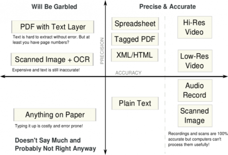
 Josh Tauber (the guy behind GovTrack) recently wrote a book on Open Government Data. I think the chapter where he walks through the process of scraping and building a visualization is great, this kind of thing should be required reading for all non-coders who are interested in technology and transparency issues. It walks through really practical examples of why formats matter. Also liked the figure on the right for locating the strengths of various types of data formats with respect to intended use. Makes the great point that a “high-quality” electronic document isn’t always better for some purposes.
Continue reading Open Government Data →
This is a catchall post to collect together a number of interesting network images I’ve run across in the last few years. The common feature is that they are all networks that are based in or arise from geography or spatial processes. Unlike most of the networks we often have to work with, these are mostly “planar” (or nearly so) meaning that they can usually be drawn in two dimensions with minimal crossing and distortion.
The map itself
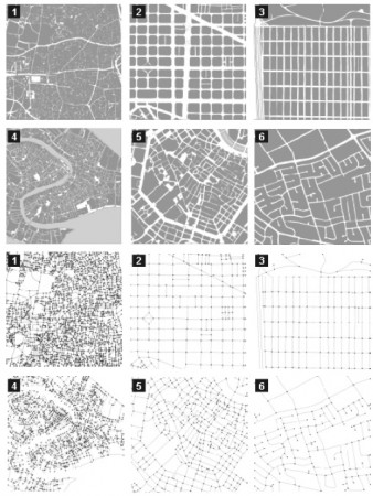
 In The Network Analysis of Urban Streets: a Dual Approach Sergio Porta, Paolo Crucitti and Vito Latora convert city streets to networks and examine some of their properties. Figure 2 of the paper below
The six 1-square mile samples of urban patterns (above) and their primal graphs (below): 1. Ahmedabad; 2. Barcelona; 3. San Francisco; 4. Venezia; 5. Wien; 6. Walnut Creek. Cities are so diverse that, at a first sight, it seems hard to imagine that they share any common — though hidden — pattern, which is what they actually do.
Continue reading Plane Old Networks →
curiosities of culture, communication & networks
 Josh Tauber (the guy behind GovTrack) recently wrote a book on Open Government Data. I think the chapter where he walks through the process of scraping and building a visualization is great, this kind of thing should be required reading for all non-coders who are interested in technology and transparency issues. It walks through really practical examples of why formats matter. Also liked the figure on the right for locating the strengths of various types of data formats with respect to intended use. Makes the great point that a “high-quality” electronic document isn’t always better for some purposes.
